
The legal description of a property is an indispensable element in the realm of real estate, acting as the precise language through which ownership and property boundaries are defined and protected. Distinct from postal addresses or informal descriptions, a legal description provides an exact, detailed, and unambiguous depiction of a property’s physical location and boundaries, which is essential for all real estate transactions, disputes, and developments. For investors, homeowners, and legal professionals in 2026, understanding the nuances and applications of legal descriptions remains fundamental to safeguarding property rights and ensuring clarity in the intricate landscape of real estate ownership and management.
Key Points About Legal Description and Property Boundaries:
- A legal description serves as the official language for defining exact property boundaries and ownership rights.
- There are multiple types of legal descriptions used across the United States, including metes and bounds and lot and block systems.
- Land surveys play a pivotal role in establishing or verifying legal descriptions, thus influencing property deeds and title descriptions.
- Accurate legal descriptions help prevent disputes over property lines and are crucial in title insurance and real estate transactions.
- Recent trends and policies in 2026 emphasize the growing importance of technology and digital mapping in refining legal descriptions.
Different Types of Legal Descriptions and How They Define Property Ownership
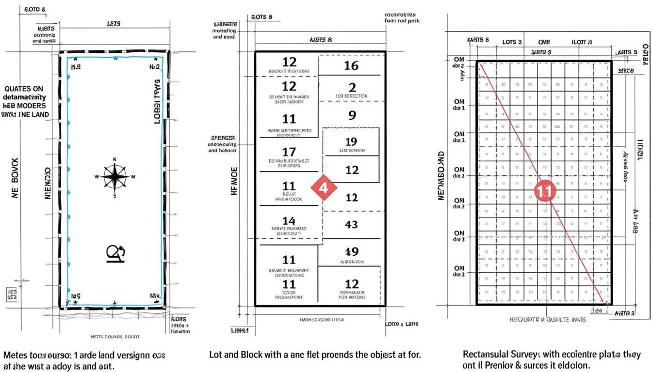
A foundational aspect of understanding property ownership lies in recognizing the types of legal descriptions commonly employed in real estate across the United States. The primary methods include metes and bounds, lot and block, and rectangular survey systems. Each system is distinct in approach and historical application, shaping how property boundaries are established and communicated.
Metes and Bounds: The Oldest and Most Detailed Method
This system relies on detailed narratives describing distances, angles, landmarks, and compass directions to outline the perimeter of a parcel. For example, a metes and bounds description might start at a permanent marker, such as a tree or a stone, and follow measured distances along multiple directions until the boundary is closed. Its origins date back several centuries, making it particularly prevalent in Eastern states where land was first subdivided.
While rich in detail, this method can sometimes lead to ambiguities if natural landmarks change or measurements aren’t precise, creating challenges in modern contexts. Yet, it’s irreplaceable in identifying older properties whose surveys predate standardized grid systems.
Lot and Block: The Foundation of Urban Real Estate
In contrast, the lot and block system is widely used in suburban and urban areas platted for development. It breaks land into tract parcels identified by a specific lot number within a block as recorded on a subdivision map filed with local government offices. This system simplifies the identification of small parcels within a neighborhood or a town and makes property transactions more straightforward.
This method’s clarity and simplicity make it the default for developers and municipalities when subdividing land for housing or commercial projects. However, it requires the existence of an official plat or subdivision map.
Rectangular Survey System: Organizing the Western States
Beyond metes and bounds and lot and block, the rectangular survey system, also known as the Public Land Survey System (PLSS), divides land into a grid of townships and ranges. Predominantly used in western states such as Texas and Colorado, this system facilitates large-scale land identification through meridians and baselines, offering a uniform approach for rural and undeveloped land.
Its reliance on mathematical grid coordinates makes it particularly compatible with modern GIS (Geographic Information Systems) technologies, allowing detailed mapping and easier integration with parcel identification systems today.
The Critical Role of Land Surveys in Defining Property Boundaries and Legal Descriptions
A land survey is the professional process that translates a property’s legal description into physical reality by determining the location and lines of a parcel of land in relation to its neighbors. The surveyor’s meticulous work ensures that the property’s boundary is clearly established, minimizing potential conflicts and disputes.
Surveying Techniques and Their Impact on Legal Descriptions
Modern surveyors employ an array of technologies including GPS, total stations, and drone imaging to pinpoint property boundaries with remarkable accuracy. Such data not only confirms the dimensions outlined in existing deeds but also updates or clarifies ambiguous descriptions. A land survey could reveal discrepancies between a property’s deed and current physical markers, necessitating legal review or adjustment in title descriptions.
For example, in several 2026 cases, timely property surveys have helped homeowners correct encroachments or easements that were improperly recorded decades ago, protecting their property ownership and investment.
The Importance of Surveys in Real Estate Transactions
Before closing a property sale, an updated land survey is often required to confirm that what is being transferred matches the legal description in the deed. Title companies rely on these surveys to issue insurance protecting buyers and lenders. Recognizing local norms around survey requirements is essential, as detailed in guidelines for property survey prices and standards in 2026.
Additionally, surveys assist in planning for improvements, boundary disputes, or subdivision of land, providing an indispensable foundation for real estate law and property development.
How Legal Descriptions Influence Real Estate Transactions and Property Ownership Clarity
Legal descriptions underpin every aspect of property ownership by enabling precise identification and transfer of land rights. Unlike common addresses, they hold primacy when recording deeds, settling title disputes, or clarifying ownership.
Deeds and Title Description: The Backbone of Ownership Records
A deed incorporates the legal description to specify exactly what land is being conveyed from seller to buyer. This specificity protects against ambiguity that could otherwise undermine the transaction. Any inconsistency in the legal description may cause title insurance problems or lead to protracted legal battles.
For instance, in complex urban areas where historical lot and block descriptions exist alongside modern developments, the exact legal description can be the deciding factor in ownership disputes or property tax assessments.
Legal Descriptions and Their Effect on Property Boundaries Disputes
Disagreements over property lines often hinge on the precision of the legal description. When descriptions are vague or outdated, neighbors might contest boundaries, leading to costly litigation. Courts generally give precedence to the written legal description supported by land surveys, emphasizing the importance of well-drafted legal documentation.
Real estate attorneys play a significant role in interpreting and resolving such cases, found in various resources including advice on real estate legal expertise in specific jurisdictions.
Technological Advances Enhancing Legal Descriptions and Property Mapping in 2026
The advent of digital mapping technologies and Geographic Information Systems (GIS) has revolutionized how legal descriptions are created, stored, and interpreted. Integrating advanced data analytics with traditional surveying methods provides unprecedented accuracy and accessibility for all parties involved in real estate.
GIS and Digital Parcel Identification Systems
GIS technology enables real-time visualization and analysis of property boundaries layered over satellite imagery and municipal records. Digital parcel identification systems allow governments, developers, and buyers to access legal descriptions and related property data instantly, streamlining due diligence and planning.
For example, county property appraisers today integrate GIS into their evaluation processes, making information transparent and helping residents understand their property’s legal framework, as demonstrated in localized tools described on understanding the roles of property appraisers.
Blockchain and Secure Recording of Legal Descriptions
Emerging blockchain technologies are being piloted to securely record and verify legal descriptions and property deeds, aiming to reduce fraud and errors common in manual record-keeping. This innovation has the potential to transform the accuracy and trustworthiness of property ownership records nationwide.
Such initiatives align with growing market demands for transparency and efficiency in property transactions projected throughout 2026 and beyond.
Practical Steps to Verify and Use Legal Descriptions Effectively in Real Estate Deals
Whether purchasing a family home, investing in commercial real estate, or conducting title searches, understanding how to verify and utilize legal descriptions properly is crucial for anyone involved in the property market.
Common Practices to Confirm Legal Description Accuracy
- Obtain and review a recent land survey from a certified surveyor.
- Compare the survey with the legal description in the property’s deed and title report.
- Consult with a real estate attorney to interpret any ambiguities or discrepancies.
- Examine local property records and maps for additional parcel identification information.
- Confirm boundary monuments or markers in the field during a site visit.
Helpful Resources and Legal Support for Property Ownership Clarity
Working with professionals such as real estate attorneys and licensed surveyors ensures the legal description you rely on is correct and binding. Additionally, numerous resources provide guidance on property law nuances, including real estate lawyer fee structures and local property search tips, enhancing your capacity to navigate property ownership clearly and confidently.
| Step | Action | Reason |
|---|---|---|
| 1 | Get updated land survey | Verify physical boundaries against legal description |
| 2 | Review deeds and title information | Identify discrepancies or errors in documentation |
| 3 | Consult with legal experts | Interpret complexities and resolve disputes |
| 4 | Research public property records | Gain more comprehensive parcel identification data |
| 5 | Perform physical boundary check | Ensure actual property markers correspond to documentation |